• Scam Alert. Members are reminded to NOT send money to buy anything. Don't buy things remote and have it shipped - go get it yourself, pay in person, and take your equipment with you. Scammers have burned people on this forum. Urgency, secrecy, excuses, selling for friend, newish members, FUD, are RED FLAGS. A video conference call is not adequate assurance. Face to face interactions are required. Please report suspicions to the forum admins. Stay Safe - anyone can get scammed.
  • The 2026 Calgary Area Meetup is set for Saturday May 30th at 10am. The signup thread is here! Robinhood has graciously offered to host the meetup again this year. Please note that you MUST RSVP to the notice linked above if you wish to come.

Really ?

One winter it took me 8 hours to get from Lloydminster to Spruce grove ....

Dodge those codfish
I live and worked 47km from Regina. My record is 3 hours getting home and that was no ditch time. Just waiting for the blowing snow to clear enough to see the tufts of grass along the side of the road allowance so you could tell where the crown of the grid was.
Which makes me wonder...If farmers can have gps systems for their equipment that gives them accuracy to the inch, why can't the same be done for vehicular traffic? Or can it, and it is just a matter of cost?
 
Just waiting for the blowing snow to clear enough to see the tufts of grass along the side of the road allowance so you could tell where the crown of the grid was.

Snow storms are like that here too every so often. We also have fog. Sometimes the fog is so bad you can't see your hood ornament. You just wait till the clearing between ground level clouds and pray that the other guy with GPS guidance doesn't assume he is alone in the road.

Which makes me wonder...If farmers can have gps systems for their equipment that gives them accuracy to the inch, why can't the same be done for vehicular traffic? Or can it, and it is just a matter of cost?

The technology for that could easily be done for cars too. It's all the other stuff that makes that impractical. Pedestrians, other non-equipped cars, road hazards, international standards, certification differences, etc etc. The hardware is the easy part.

Another often forgotten part of cm level GPS Guidance is the base station. RTK guidance at that level of precision needs a reference signal to correct the location. Access to those reference signals is expensive (thousands per year) unless you make your own (which I did). The problem with making your own is that it only works within radio range of the base to rover connection. You can also connect via cellular, but that only works within the correction range of the base.

I built my own system for use on my farm, so I can expand on that if you want to know more.
 
I live and worked 47km from Regina. My record is 3 hours getting home and that was no ditch time. Just waiting for the blowing snow to clear enough to see the tufts of grass along the side of the road allowance so you could tell where the crown of the grid was.
Which makes me wonder...If farmers can have gps systems for their equipment that gives them accuracy to the inch, why can't the same be done for vehicular traffic? Or can it, and it is just a matter of cost?
The Massey Tunnel in Vancouver was built in 1959, and runs four narrow lanes of traffic for underneath the Fraser River. I've seen drivers going through the Tunnel in rush hour while reading a book placed on their steering wheel. Ladies driving while using the visor mirror to apply makeup is very common. So how will they decide which takes priority - makeup, book or GPS?
 
I built my system around a low cost gps receiver. It's just a matter of designing and building circuits, boxes, providing power, programming, rain proofing, calibration, and a good antennae. And lots and lots of trouble shooting. I use a commercial app on my phone or tablet to manage my field plans.

There is a rover that attaches to my tractor and a base station by the house that work together to achieve an RTK 1cm signal. Basically, the base already knows exactly where it is. It receives a gps signal, and calculates a correction between where the gps signal says where it is and where it really is. Then it sends that correction to the Rover on a real time basis. The rover gets the same satellite signal and then corrects that to where it really is using the correction info from the base.

Lots of mapping programs available on line - some are free.

Why? I am a relatively small farmer. Bigger than a hobby farm but much smaller than a corporate farm. I cannot afford my own combine so I have to hire that out. The first time you pay a guy to combine your corn with crooked rows will be the last time he combines for you. Word spreads fast. Row markers only get you so straight. One cm GPS guidance is the only way to go for precision planting and arrow straight rows that are easy to combine.

But beyond that, it's amazing how much better you can plow, cultivate, disk, spread fertilizer and spray with gps guidance. Saves fuel, saves time, reduces product cost and achieves more efficient overlap. You don't even have to make each pass adjacent to the last. Just make a pass and let the GPS calculate the rest and help you choose the 2nd, 3rd or nth pass. Just imagine cutting grass without cutting each pass right next to the last. Cut whichever pass you want and then pick whatever next pass you want. Makes turning easier and keeps everything lined up. Prolly saves 20% just by taking overlap down to as little as you want. When fuel, seed, and fertilizer costs are sky high, GPS guidance pays for itself in the first year.
 
So a super quick and easy job. Buggered it up royally. Try again, same result. They say third times a charm, well bugger them too. 4, 5, 6, 7, stubborn, persistent, call it what you will. Give up for the day. Back to it this morning, 10 minutes, perfect part first try.
Really ?
 
I live in Vancouver. A 20km drive can get you through twelve different weather systems. Ten of them will be varying degrees of rain, based on velocity, density, and size of rain drops.
Hi Guys,

Several times Its been raining heavily and the other side of the white line is as dry as a desert ! Weird.
 
So a super quick and easy job. Buggered it up royally. Try again, same result. They say third times a charm, well bugger them too. 4, 5, 6, 7, stubborn, persistent, call it what you will. Give up for the day. Back to it this morning, 10 minutes, perfect part first try.
Really ?
You know it's getting bad when you start looking around to see if anyone is watching....... I think we have all been there, I just wish I would quit buying the t-shirts.... 🙄
 
Stuff from "over seas" is not always cheap junk - really? I mean, really.

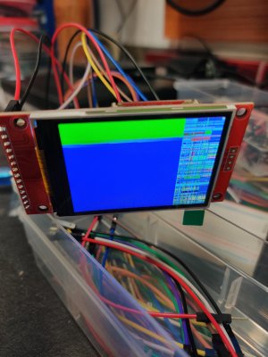
This cheap electronic display got molly whopped by my incompetence and somehow survived. Read several online comments about how careful you have to be or you can destroy it. Don't touch the metal sides, don't apply the wrong voltage, don't disconnect leads with it still powered "ON"...I did all of that and more (not intentionally). The only thing I didn't do was punt it across the room out of frustration. Spent a few hours trying to get it to work. The packaging came with very little information and identification (typical from AliX - I wasn't surprised). A reverse image look-up of the rear panel finally saved the day. Hit the mother load of information, specs, test code, etc.

Now for step 2 in the project.😕

Display.jpg
 
I live and worked 47km from Regina. My record is 3 hours getting home and that was no ditch time. Just waiting for the blowing snow to clear enough to see the tufts of grass along the side of the road allowance so you could tell where the crown of the grid was.
Which makes me wonder...If farmers can have gps systems for their equipment that gives them accuracy to the inch, why can't the same be done for vehicular traffic? Or can it, and it is just a matter of cost?
You may be able to soon, if the Chinese EVs are imported with the self driving capability, they will have to use use the high precision Chinese BeiDou gps equivalent that gives 160 centimeter horizontal accuracy.
 
Stuff from "over seas" is not always cheap junk - really? I mean, really.

This cheap electronic display got molly whopped by my incompetence and somehow survived. Read several online comments about how careful you have to be or you can destroy it. Don't touch the metal sides, don't apply the wrong voltage, don't disconnect leads with it still powered "ON"...I did all of that and more (not intentionally). The only thing I didn't do was punt it across the room out of frustration. Spent a few hours trying to get it to work. The packaging came with very little information and identification (typical from AliX - I wasn't surprised). A reverse image look-up of the rear panel finally saved the day. Hit the mother load of information, specs, test code, etc.

Now for step 2 in the project.😕

View attachment 76781
So when you do get it working on the build, is the screen ok? I'm just asking cause of the 2 distinct differences in the display. I know zero about building electronics, so when I see that kinda thing, my first assumption is its FUBAR.
What are you making anyway?
 
So when you do get it working on the build, is the screen ok? I'm just asking cause of the 2 distinct differences in the display. I know zero about building electronics, so when I see that kinda thing, my first assumption is its FUBAR.
What are you making anyway?
The screen is showing one stage of several as it's running through a "graphic test".
I will be using it to replace the failing display on an old multimeter. Following someone else's online project.
 
Back
Top